![[Valid Atom 1.0]](valid-atom.png "Validate my Atom 1.0 feed")


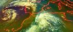


NASA satellite altimetry data are being used in combination with data from other satellites to track changes in a huge warm ocean current in the Gulf of Mexico that could transport oil from the Deepwater Horizon oil rig far away from the Gulf. Image credit: NASA/JPL/University of Colorado


