![[Valid Atom 1.0]](valid-atom.png "Validate my Atom 1.0 feed")


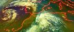


The number of fires burning in Brazil more than doubled since last year, sparking a Twitter sensation, with more than 120,000 users "tweeting" messages with the hashtag "#chegadequeimadas" about fires in a 48 hour window.
The phenomenon emerged after analysis of satellite data by Brazil's National Institute for Space Research (INPE) revealed the number of "hot spots" between Jan 1 and Aug 16 reached 30,825 in 2010, up from 15,228 for the same period last year.
Alberto Setzer, coordinator of INPE's fire monitoring program, blamed drier and warmer conditions, as well as socio-political factors, like higher commodity prices and upcoming national elections. Afraid of alienating key supporters in the agricultural sector, Setzer told Terra Brasil that politicians are laying off environmental law enforcement under after elections. Uncertainty about the Brazilian environmental legislation - including a possible weakening of the country's strict Forest Code - might also be having an impact.
Fires in the Brazilian Amazon are generally set by developers opening logged forests, deforested scrub, and grassland for pasture and agriculture. Under dry conditions fires often "escape" into adjacent rainforest areas, casting a pall over much of Brazil and in some years affecting transportation and air quality. Fires usually burn until September or October when the rainy season resumes. This year fires are especially concentrated in the drier, but more populated, northern and eastern parts of the country. 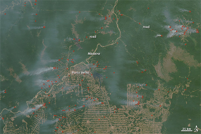
>On August 7, 2010, fires burned along the Madeira River in the vicinity of Porto Velho, the capital of Rondônia, Brazil. The Moderate Resolution Imaging Spectroradiometer (MODIS) on NASA’s Aqua satellite captured this natural-color image the same day. Red outlines indicate high surface temperatures associated with actively burning fires, and pale gray smoke plumes arise from most of the hotspots. At first glance, the placement of the fires might appear random, but a close look indicates that the fires burn close to cleared lands, particularly near roads. The characteristic herringbone pattern of deforestation spreads across much of this image, especially in the south. Many of the fires burn along the fringes of such cleared areas. NASA image by Jeff Schmaltz, MODIS Rapid Response Team. Caption by Michon Scott.
Despite the rise in burning, deforestation in the Brazilian Amazon is expected to be roughly the same as last year — around 7,000 square kilometers — when figures are released later this year. If the forecast is correct, it will continue a trend of markedly lower deforestation than levels seen from the 1980s until about five years ago.
Nevertheless environmentalists fear that a suite of proposed infrastructure projects could accelerate deforestation in the future despite a pledge by the Brazilian government to reduce deforestation significantly by 2018.
Brazil contains the bulk of the world's remaining tropical rainforest, but substantial parts of the country are covered with cerrado grassland, which is more susceptible to fire than forest.


Nenhum comentário:
Postar um comentário